Passive Drone
Detection.
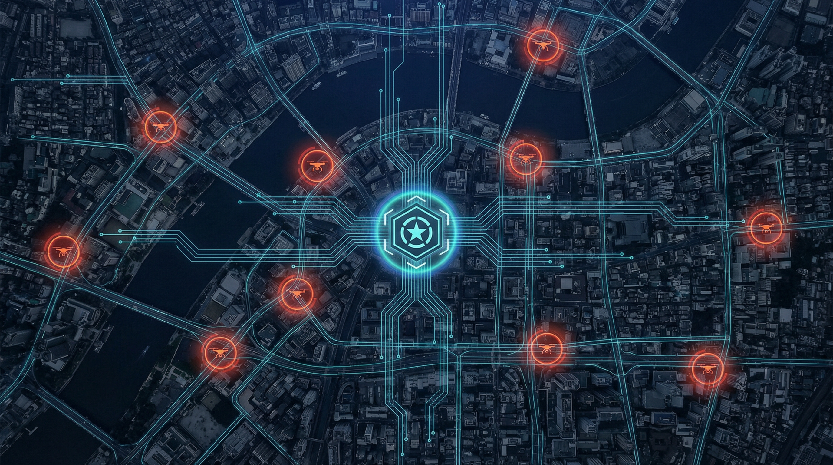
City-Scale Coverage.
MEGUV delivers a patent-pending, AI-powered detection platform that identifies, classifies, and tracks unmanned aerial threats across entire metropolitan areas — with zero RF emissions and zero blind spots.
Threat Assessment
The Drone Threat Is Outpacing Current Defences
Conventional radar and RF-based counter-UAS systems are failing against the new generation of autonomous, low-signature aerial threats. The gap between threat capability and detection capability is widening every month.
Over the past 3 years at critical infrastructure sites
Of low-altitude urban airspace invisible to conventional radar
Autonomous drones emit zero RF — invisible to RF detection
Typical single-sensor C-UAS systems in urban environments
Core Technology
Proprietary Detection Platform
Something already surrounds every city, every base, every critical asset you protect. MEGUV's patent-pending technology reveals what it can really do. The methodology is classified — the results speak for themselves.
Detailed technical architecture and sensing methodology available exclusively to verified defence procurement officials under NDA.
Proprietary Sensing
A patent-pending detection architecture that activates a capability hidden in plain sight. Persistent, wide-area aerial surveillance that adversaries will never see coming.
Completely Passive
Zero RF emissions. No radar signature. The system is invisible to adversaries and cannot be detected, jammed, or targeted by hostile electronic warfare.
Real-Time Processing
Advanced AI-powered processing delivers event detection, classification, localization, and tracking in milliseconds — from first contact to actionable alert.
Privacy by Design
The system architecture is fundamentally privacy-preserving. It has no capability to access, intercept, or inspect any communications data whatsoever.
Multi-Layer Classification
Proprietary machine learning models distinguish between threat categories with over 94% accuracy — including autonomous platforms invisible to conventional systems.
City-Scale Coverage
A single deployment can monitor thousands of kilometers of coverage area, providing persistent aerial surveillance across entire metropolitan regions.
Operational Pipeline
From Detection to Threat Alert
Six-stage processing pipeline transforms raw sensor data into actionable intelligence in milliseconds.
Infrastructure Activation
Patent-PendingMEGUV's proprietary technology awakens a latent capability already embedded in the world around you. Activation is rapid, covert, and requires minimal footprint.
Threat Signature Detection
ProprietaryAerial threats generate distinctive signatures that are captured by the activated sensing network. The system detects even low-signature, autonomous platforms invisible to conventional sensors.
AI Classification
Machine LearningAdvanced machine learning models classify the detected threat by type — multicopter, fixed-wing, loitering munition, or rotorcraft — with classification accuracy exceeding 94%.
Geospatial Localization
ProprietaryThe system estimates geographic coordinates, altitude, heading, and velocity of detected threats with confidence bounds, using proprietary multi-point localization algorithms.
Persistent Tracking
ContinuousContinuous track states are maintained automatically. The system handles track initiation, confirmation, occlusion, and re-identification across the entire coverage area.
C2 Cueing & Response
AutomatedGeoreferenced alerts with track ID, heading, speed, and threat score are transmitted to command systems, cameras, radar, and counter-UAS effectors in real time.
Operational Capabilities
City-Scale Aerial Dominance
One system. Thousands of kilometers of coverage. Every aerial threat detected, classified, tracked, and reported.
Classification Accuracy
Detection
- Low, slow, small targets
- Autonomous drones (no RF)
- Swarm detection
- Night & all-weather
Localization
- Geographic coordinates
- Altitude estimation
- Confidence bounds
- Corridor identification
Tracking
- Persistent track state
- Heading & velocity
- Trajectory prediction
- Multi-target handling
Classification
- Threat type identification
- Confidence scoring
- Nuisance rejection
- Unknown threat flagging
Processing
- Real-time pipeline
- Sub-500ms latency
- Scalable architecture
- Continuous adaptation
Integration
- C2 system cueing
- Camera slew-to-cue
- Counter-UAS handoff
- Multi-sensor fusion
System Integration
MEGUV operates as the primary passive wide-area detection layer, cueing downstream sensors — radar, PTZ cameras, RF direction finders, thermal imagers — for confirmation and response coordination.

Deployment Scenarios
Operational in Hours, Not Months
MEGUV activates what's already in place — deploying at a fraction of the cost and time of any conventional counter-UAS system.
Metropolitan
City-wide coverage activated overnight. Thousands of km of persistent aerial surveillance with zero civil works or visible installations.
Critical Infrastructure
Power plants, water treatment, government buildings. Perimeter and approach-corridor monitoring with covert, persistent coverage.
Airports & Airfields
Runway and approach path protection. Detect and track unauthorized drones before they enter controlled airspace.
Industrial & Energy
Oil refineries, pipelines, substations. Continuous monitoring of restricted airspace over high-value assets.
Military Installations
Base protection and forward operating bases. Passive detection that doesn't reveal defensive positions.
Border & Perimeter
Long-range linear monitoring along borders, coastlines, and restricted zones — covert and persistent.
Comparative Analysis
Why MEGUV Outperforms
| Capability | MEGUV | Radar | RF Detection | Camera / EO |
|---|---|---|---|---|
| Detection Method | Proprietary passive sensing | Active RF emission | Passive RF intercept | Visual / thermal |
| Detects Autonomous Drones | ||||
| No RF Emissions | ||||
| All-Weather Operation | ||||
| Night Operation | ||||
| Urban Environment | ||||
| Coverage Per Unit | 50+ km | 5–10 km | 2–5 km | 1–3 km |
| Deployment Footprint | Minimal & Covert | Extensive | Moderate | Moderate |
| Deployment Time | Hours | Months | Weeks | Weeks |
| Operating Cost | Very Low | Very High | High | Moderate |
| Privacy Compliant |
Assessment based on typical operational conditions. Detailed performance data available under NDA.
Intellectual Property
Patent-Pending Innovation
MEGUV's core technology is protected by a comprehensive utility patent specification with 30 claims spanning system, method, and computer-readable medium categories.
Utility Patent Specification
Claim Coverage
System Claims
12Comprehensive coverage of the complete detection, classification, localization, and tracking system architecture.
Method Claims
12Protection of the proprietary processes and algorithms from sensing through to operational cueing output.
Computer-Readable Medium
6Software and AI model protections covering the machine learning classification and signal processing pipeline.
Patent pending. Full specification available to verified defence procurement officials under NDA.
Get In Touch
Request a Classified Briefing
MEGUV is available for defence procurement, critical infrastructure protection, and government security programs. Contact our defence sales team for a classified technical briefing and capability demonstration.
Detailed technical specifications and deployment architecture documents are available to verified defence procurement officials under appropriate security clearance and NDA.